I climbed Mt. Fuji at the end of August. I wanted to do this last year but it was too late.
Mt. Fuji is open from July 1st to August 26th. During this term we can stay at mountain lodge, buy supplies, and use aid station. After August 26th, most of the lodge and all of aid station are closed. It means that we can't buy water, oxygen, no toilet or no help from aid station even if you were injured. Some professionals climb Mt. Fuji in winter as training before Mt. Everest.
About Mt. Fuji
As you know the height is 3776m and it's the highest mountain in Japan. The average temperature of the top is 6 degree in August.
Step counter
I bought some equipment for climbing such as water, oxygen, food, head light, gloves and
step counter.
Step counter counts your steps. When I walk 10 steps, it counts my steps and it shows "You walked 10 steps. It is about XX km. And you consumed XX kcal". I wanted to take it Mt. Fuji or travel. Because it's difficult to estimate how far I walked in a day when I'm traveling especially in foreign countries.
 This is cheap nowadays.
When I'm in office in a day, it counts about 3500steps. |
Shinjuku station - 19:50
We went to Shinjuku station to take a high way bus at 19:50. To the take bus, reservation is required in advance. The bus goes to Mt. Fuji 5th station. The altitude of 5th station is 2305m.
5th station - 22:00 at 2305m - 0.0km walk - Fun!
When we arrive at 5th station, it was cold. It was about 15 degree there. We changed our clothes, prepared equipments then started to climb from Fujiyoshida entry. There are some entries in Mt. Fuji.
 There were lots of climbers.
 |
 Many people buy this stick (about 10 USD) to climb. You can see people who have this at Shinjuku station west exit. They just came back from Mt. Fuji by bus.
 |
 The slope is easy and the path is gravel walk here. This is not like climbing. Just walking.
 |
6th station - 23:45 at 2390m - 2.29km walk - Happy!
It is still easy. It's just started.
 Arrived at 6th station.
 |
 Good road. Easy to walk.
 |
7th station - 1:20 at 2700m - 4.39km walk - Lovely! It's getting difficult and cold. Slope is steep and road is rocky. Head light is very useful to find a place to step on.
 7th station.
 |
 There are many mountain lodges on the way. We can buy food, water, sleep. But you have to make a reservation in advance.
 |
 We have to pay for using toilet. It's about 2-3dollar.
 |
 I thought Mt. Fuji is rally good place for dating. Cold wind is very comfortable in summer. Night view is so beautiful. Silent...
 |
 Little cliff. But not that difficult yet.
 |
8th station - 3:30 at 3020m - 5.75km walk - Something wrong??
 Almost morning.
 |
 There aren't so many rocks. Easy to walk here.
 |
 Sunrise.
 |
 Sunrise.
 |
 Sunrise.
 |
 I was taking many pictures and kidding around here so much.
 |
 Then I had altitude sickness.
 |
 There are steps. It's easy but little headache...
 |
 Everything is expensive here. 4-6dollar.
|
Extra 8th station - 3:30 at 3360m - 7.73km walk - Got sick...
This is final stage. The slope isn't so steep but the air is very thin. I didn't notice the thin air but headache told me that. I took little rest every turns of the road to minimize headache. I saw many people apart form their party. Each of them had to take rest separately as they want. I thought I shouldn't come here with a girlfriend. I'm sure we'll fight together. Actually after I came back from Mt. Fuji, I heard that one of my friend did it before. First it was like a dating. Last it was like a hell and finally fight...
I was not tired but headache was troublesome.
 Extra 8th station. This is next station of 8th statin. Not 9th station.
 |
 People take rest everywhere beside the load. Sometime I slept for a moment because I didn't sleep long time and kept walking.
|
 Those people were climbing down after they saw sunrise at the top of mountain. We couldn't reach there before sunrise. To see sunrise, stay at mountain lodge at night and go to the top early in the morning.
|
 So many people here.
 |
 If you see this shrine gate, you'll arrive at top very soon.
|
Top - 9:20 at 3776m - 9.75km walk - Fine!
Finally we arrived at the top of Mt. Fuji.
 I was fine and no headache because I was happy to be here? Actually I took aspirin and it was working. But I think my feeling empowered the effect!
|
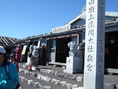 Shrine at the top of mountain.
 |
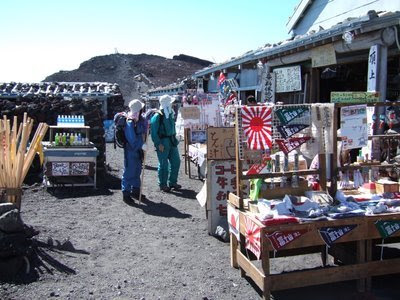 Souvenir shops.
|
 People can work abound the crater. It takes 1 hour. But we had no time to do it. I wanted to see a post office here.
|
 Summit crater of Mt. Fuji.
|
 Mr. K doesn't care about thin air at all. I can't believe it.
|
 Then we stared to climb down. It is very dusty.
 |
 Mask is useful to prevent dust.
 |
 This sandy way is very famous. It's really easy to go down quickly.
|
5th station - 14:50 at 2305m - 19.14km walk - Where is toilet!?
Finally we arrived at 5th station in Gotenba entry. Here is other entry where we started to climb.
 I don't know why there are not so many toilets on the way back. There was only one rest place. I was about to die!
 |
I like it but...
Now Mt. Fuji is kind of touristy place. It is not so difficult to climb up and you don't lose the way. There are many directions and aid stations in summer. You don't need to be afraid if you prepare proper equipment in advance. You can see little kids or elderly on the way.
On the other hand, altitude sickness is the biggest problem in Mt. Fuji. If you have experience of climbing mountains, try to slow down. I have some experience and I'm little good at climbing mountains but I haven't climbed up such a high mountain before. So I climbed up Mt. Fuji quickly as usual. Finally it caused altitude sickness.
When you are climbing Mt. Fuji, you'll be dirty, you have a risk of sunburn, altitude sickness, your legs will be gone, and you can't sleep for long time (for me I couldn't sleep for 39 hours. It was my new record!), preparation is a bother... But Climbing Mt. Fuji and everything that I listed were very good experience for me. Now I understood what climbing Mt. Fuji is like.
But don't ask me to climb it up again. I'm sure I won't...
Reference
Here is a interesting table.
| Start Date Time | Station | Walking Distance[km] | Spent Time[h:mm] | Velocity[km/h] |
|---|
| 2005/8/19 23:05 | 5-6 | 2.29 | 0:49 | 2.80 |
| 2005/8/19 23:54 | 6-7 | 4.39 | 2:24 | 1.33 |
| 2005/8/20 1:29 | 7-8 | 5.72 | 4:32 | 0.63 |
| 2005/8/20 3:37 | 8-Ex8 | 7.73 | 7:27 | 0.69 |
| 2005/8/20 6:32 | Ex8-Top | 9.75 | 10:27 | 0.67 |
| 2005/8/20 9:32 | Top-5 | 19.14 | 15:53 | 2.12 |